Posts

Showing posts from August, 2019

Paducah’s history

Image

Pushing rocks

Image
When the boat is going fast (fast means 21-25 mph), and I abruptly shut down the engine, the stern settles down, with a pause, and then the boat surges forward, riding its own wave. That seems so for the trip also. Having shut down the throttle, I surge back into normal life. A shower was top priority. AirBNB provided an elegant bedroom in the house of the former mayor. She said she lost reelection because of her support for the city owned transient dock, the place where my boat is tied.  The dock was controversial. She said what got the project started was a $1.5 million federal grant, thanks to Senator McConnell. This is the only occasional I have found to think well of him.  She was unhappy because Owensboro got $5 million for their waterfront project. Anyway, rocks. I have tried to learn from Sisyphus, who spent his afterlife pushing rocks up hill, only to have them roll down while he slept. For eternity!  I looked up Sisyphus, and he probably deserved it. For much ...

Cave in the Wall

Image
Cave in the Wall has fed the imagination since the 1700s. River rowdy’s and pirates would gather there to plunder innocent passersby, and probably drink lots of whisky at the same time. The original party spot of the Ohio. Wabash Island Mile 851 Lonnie Lewis, ferryman, farmer Downriver at Cave In The Wall I stopped for breakfast at Rose’s Kountry Kitchen. A ferry crosses the river here. No fare to cross. The states pay. Lacking a better choice, I tied up to a nest of small towboats which had a derelict appearance. They had to be part of the ferry operation, which use a tow to guide a ferry barge. Knowing that the ferryman would see me, it was either going to be okay or not. It was not. The ferry owner showed up before I hit the shore. I couldn’t stay there, by policy. So we stood and visited. He talked with the authority of a man who had lived here all of his 78 years. He is both ferryman and farmer. I will remember him as the Grand Old Man of the river. Here’s something he...

Life moves too fast to document...

Image
August 11 French Island No. 2 Mile 769 From yesterday morning: As I started the sun was rising at 7:00.    The location, in southern Indiana, is near the end of the time zone. Which divides the state. Now ten miles later to the Southwest, the sun had risen at 6:00. Either way it was a quiet sunrise, with low mist on the water, a light breeze and scattered clouds. I hear crows. A cow mooed. The early morning fishermen in bass boats and jon boats were drifting silently.   The River always wins. I can picture a future time when human dominance will decline or end, when the river eventually breeches the dams, flushing the pollution and empty water bottles to the oceans. Humans along this river have an uneasy relationship in some ways. When waters are quiet, the non-swimmers fear drowning in it. When it floods, as it does every spring and sometimes fall, people abandon their faith in the Army Corp of Engineers, the “River Tamers”, and head for high groun...

The Outdoorsman

Image
18 Mile Island. Mile 582 The Island The miles are counted upstream from Louisville. To say Louisville properly you’d train with a marble rolling in your mouth.  Like Cincinnati, Louisville felt unapproachable by boat. I kept moving. Louisville has some particular and easy to understand history. Before dams and locks, the most challenging part of the river was Louisville’s distinction. Boats had to go down the rapids, a downhill run of shoals and rocks. The locks were a much better choice. I had to wait for a tow, so made breakfast floating above the lock.  Another 30 miles down, I thought I found a gas source, up a stream by Westpoint KY. There I met Andrew bowfishing carp. He explained there is no season. The Star wants their numbers reduced. I explained to him I was getting gas. He said tying to a tree near the first bridge was closest. Then he offered to help. This was huge for me. The mid bank was steep and slippery. I would make three trips. With his help and ...

Friends on the river

Image
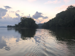
Start Mile 463, just upstream of Cincinnati  Last night I set up the boat for the usual night, but at 12:30 the rain returned.    Shower turned into heavy downpour, plus a wind from upstream (opposite the daytime pattern).. The boat could accommodate a light rain, but not this. As lightning flashed I am thundered, I lay in bed thinking about all of the rain coming aboard, and worrying that if I didn’t get up The boat could accommodate a light rain, but not this. As lightning flashed and thundered, I lay in bed thinking about all of the rain coming aboard, and worrying that if I didn’t get up, Water might come over the transom. The bow to stern heavy. I’ve pumped quite a bit while the rain continued to drill down. Back in the cabin, only my feet were damp, from a water might come over the transom. The bow to stern heavy. I’ve pumped quite a bit while the rain continued to drill down. Back in the cabin, only my feet were damp, from a leak above. Eventually the rain slowe...

Distinctions

Image
As few days ago I saw what is referred to as a “sawyer”. I wanted definition of the other terms for water hazards.     This is from a Kentucky state site: “Steamboats had to be on particular watch for different types of river hazards. “Rafts” were accumulations of logs that lodged on sandbars. Snags in the river waters came in a couple of forms. One, called “planters,” were whole trees whose roots had become embedded in the river bottom and reinforced by silt. The tree tops, limbs, and branches devastated many craft. “Sawyers” were much like planters but bobbed in the river top down with the bottom of the tree and roots cutting the water’s surface similar to a sawmill blade.” More distinctions.    Flowing into the Ohio are many ”rivers”, like the Licking River the Muskingum or Kanawha; “creeks”, and then “runs”.    Dictionary lists do not define “run”, but they are common on the Ohio. Too small to be a creek. All of this inflow reminds me that...

Am I in Paris?

Image
Start, Mile 397.  Anchored behind Little Manchester Island. As to the title, you might not expect this confusion in Kentucky. I landed in the early morning at Maysville Kentucky, to buy fuel. I check the iPhone maps to find fuel close to a municipal dock. Maysville displayed a huge Welcome to Maysville sign. Inside the levee (all towns in this section have tall levees), were some great murals of the past. Even the Underground Railway was depicted.  The newspaper office was on the corner: I couldn’t resist asking. No, they were owned by a company in South Carolina. Maybe they should become just The Ledger. Walking around a bit, I saw buildings that were beautifully restored and maintained. I bought six gallons of gas, one at a time in my portable containers. Then it was time to seek out breakfast, with the help of Yelp.  The best choice appeared to be Parc Cafe, in a corner of the old Everett Grain warehouse.  And, next thing I knew,...

Locking in the cool of the day

Image
Start Mile 314. I spent the night anchored in the upper end of a barge fleeting area, where 15 barges (3 wide by5 long) are put together in advance of the towboat’s arrival. It was good in most ways, but I did not anticipate the activity through the night. Every so often I’d be rocked so hard I thought my teeth would fall out. But I’d go back to sleep. Today, mid day, it’s already 91. My normal day plan now is to start just after dawn, preferably near the upper side of a dam. My theory is they are less busy first thing in the morning. It may not be true, but it’s worked the last few days. Today’s dam is eleven out of 19 dams. From here on the dams are about 100 miles apart. The first third of the Ohio River is steepest. As I approach the lock, I called the lock tender on channel 13, announcing the approach of a recreational vessel, and my desire to lock downstream.  For some reason the locks for are always emptied.  On this morning, nothing was going through but me. ...
Image
Gallipolis Stopped at Gallipolis, pronounced locally as galley-polis. The key bit of history of this town is not mentioned on the plaques ashore.    From Wiki: Gallipolis was first settled by Europeans in 1790: "The French 500" were a group of French aristocrats, merchants, and artisans who were fleeing the violence and disruption of the French Revolution.[12][13] They were led by Count Jean-Joseph de Barth, an Alsatian member of the French National Assembly.[14] It is the second city to be founded in the newly organized Northwest Territory of the United States. It is known as "The Old French City" because of this beginning. The Gallipolis Epileptic Hospital Stone Water Towers, built in 1892, are listed on the National Register of Historic Places. This was a time of rampant land speculation in the Northwest Territory, recently opened for settlement after it was organized following the Northwest Indian Wars. The French had worked with the Scioto Company, a pu...
Image
Ravenswood. Aug. 1. Mile 221, Ravenswood  I missed wring about Marietta.    Marietta was named for Marie Antoinette, who was still in general favor in 1788. It was a thank you for French help in the Revolution.   Marietta is rightly proud of its history as the first real town in Ohio, and a key player in the subsequent settlement of the region.    It never became a big city like Cincinnati, even though the grandeur of its public buildings anticipated a much greater population.    I’m not sure what all supports Marietta today, but Marietta College is a big part.    It was founded way back in 1835, and has 1200 students. It is regarded as one of the top    Midwest colleges.  In Marietta, like many towns along the river, the architecture is dazzling, paid for with prosperity in the past. Months ago I contacted Joe Tewksbury, coach of the Marietta High School Rowing Club.    We met at the boathouse, w...